WELCOME TO TS WEATHER STATION (TS WE-ST)

Our company plant’s Base stations so that we can develop the world with accurate rtk positioning technology.

About Us

Our company plant’s Base stations so that we can develop the world with accurate RTK technology.

What is RTK =Real-time kinematic positioning (RTK) is the application of surveying to correct for common errors in current satellite navigation (GNSS) systems. It uses measurements of the phase of the signal’s carrier wave in addition to the information content of the signal and relies on a single reference station or interpolated virtual station to provide real-time corrections, providing up to centimetre-level accuracy (see DGPS).[1] With reference to GPS in particular, the system is commonly referred to as carrier-phase enhancement, or CPGPS.[2] It has applications in land surveyinghydrographic surveying, and in unmanned aerial vehicle navigation.

Our Team

K.Rounak

(Founder)

Avinash Kumar

(Co-Founder)

Rahul

(Directors)

Krishna raj

(Directors)

EMPOWERING YOUR GNSS JOURNEY

Satellite Systems (GNSS) demands a partner that stands at the forefront of innovation

Worldwide Shipping

It elit tellus, luctus nec ullamcorper mattis, pulvinar dapibus leo.

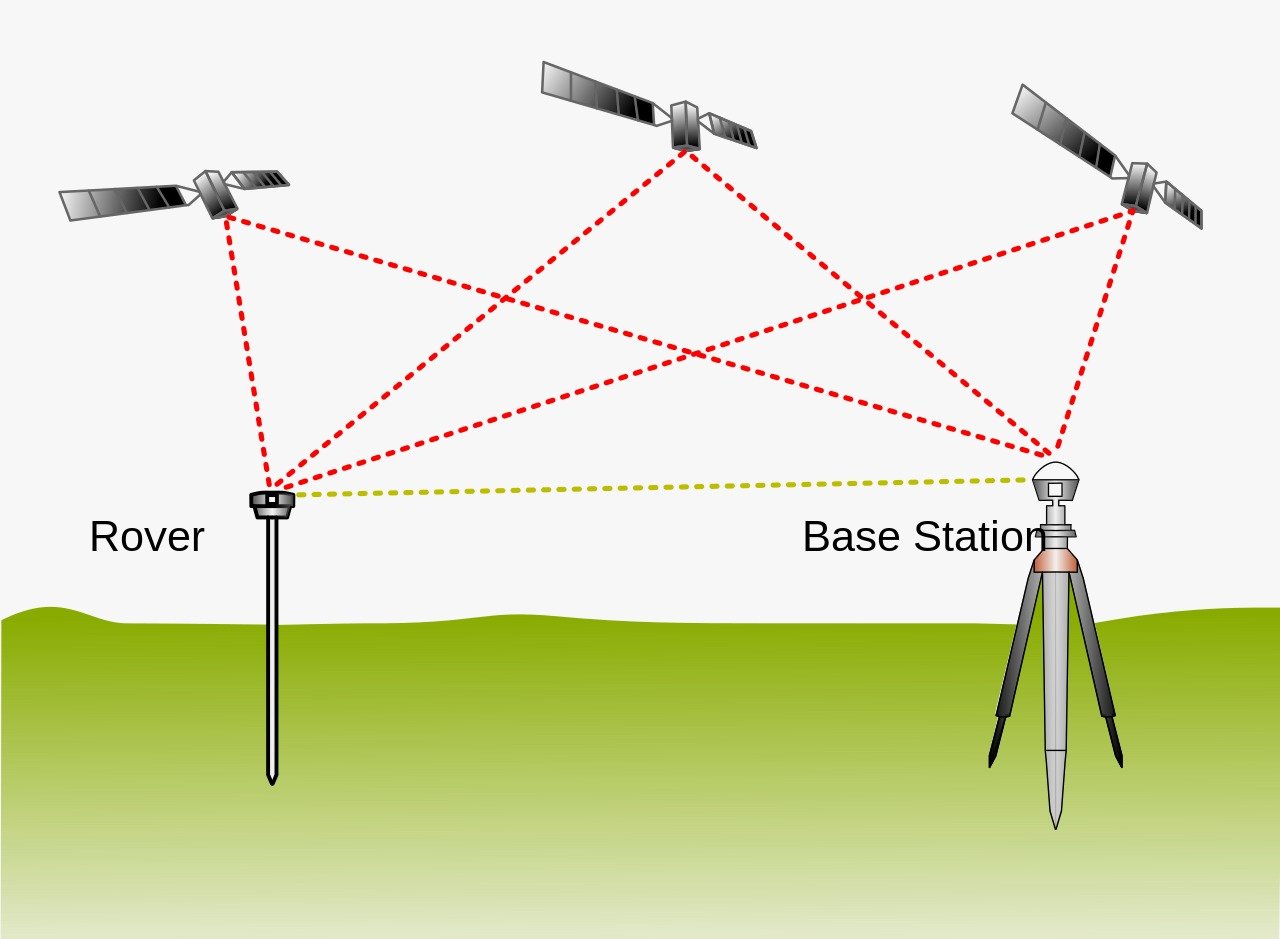
Real Time Kinematics, or RTK for short, is a special technique for satellite positioning that can produce accurate results to the centimeter, making it an invaluable tool for surveyors around the world. The method involves measuring satellite data against a ground station for precise, real time information.

imgpsh_fullsize_anim (1)

The Indispensable Need for RTK GNSS in the 21st Century

Welcome to the latest edition of MGS News! In this article, we delve into the vital role of Real-Time Kinematic Global Navigation Satellite Systems (RTK GNSS) in the 21st century. As technology continues to advance at an unprecedented pace, the need for precise and reliable positioning information becomes increasingly crucial. RTK GNSS emerges as a game-changing technology, revolutionizing various industries and enabling applications that demand high-accuracy location data. Join us as we explore the immense significance of RTK GNSS and its impact on the modern world.

Understanding RTK GNSS

RTK GNSS is a cutting-edge positioning technology that employs global navigation satellite systems to provide real-time, centimeter-level accuracy for precise positioning applications. Unlike traditional GNSS receivers, which offer only meter-level accuracy, RTK GNSS uses carrier phase measurements to mitigate errors caused by atmospheric disturbances and other factors. By employing a reference station and a roving receiver, RTK GNSS achieves superior accuracy by resolving these errors in real-time, enabling sub-decimeter level positioning.

imgpsh_fullsize_anim (2)

Unleashing the Potential of RTK GNSS

In the 21st century, where high-precision positioning has become increasingly crucial, RTK GNSS finds extensive applications across various industries. Let’s explore a few key areas where RTK GNSS has proven to be indispensable: a. Surveying and Mapping: RTK GNSS revolutionizes the field of surveying and mapping, offering surveyors unprecedented accuracy and efficiency. It enables precise mapping of land, infrastructure, and natural resources, facilitating urban planning, construction projects, and environmental studies. b. Agriculture: Precision agriculture has gained significant momentum, and RTK GNSS plays a vital role in optimizing farm management. By providing accurate positioning information, farmers can implement site-specific crop management, reducing resource wastage and improving crop yields. c. Construction and Engineering: In the construction and engineering sectors, RTK GNSS enhances project efficiency and precision. It enables precise machine control for excavation, grading, and paving operations, reducing rework and enhancing overall productivity. d. Autonomous Vehicles: The rise of autonomous vehicles relies heavily on RTK GNSS for precise positioning, enabling safe and accurate navigation. Whether it’s self-driving cars, drones, or maritime vessels, RTK GNSS ensures the vehicles know their precise location at all times, facilitating reliable and efficient transportation.

Overcoming Challenges with RTK GNSS

While RTK GNSS offers immense benefits, it is important to acknowledge the challenges associated with its implementation. One key challenge is the need for a reliable and robust network infrastructure to support the reference stations required for RTK corrections. Building and maintaining these networks require substantial investment and coordination among stakeholders. However, advancements in technology and collaborative efforts are continuously improving the availability and coverage of RTK GNSS networks, mitigating this challenge. Another challenge is the susceptibility of RTK GNSS to signal blockages or interference in urban environments or dense foliage. However, innovative solutions such as multi-constellation and multi-frequency receivers, combined with advanced signal processing techniques, are being developed to address these issues and enhance the reliability of RTK GNSS.

Future Trends and Developments

As we move further into the 21st century, the future of RTK GNSS looks promising. Several trends and developments are shaping the evolution of this technology: a. Integration with Other Technologies: RTK GNSS is increasingly being integrated with other advanced technologies such as LiDAR, computer vision, and artificial intelligence (AI). These synergies enhance the overall accuracy and robustness of positioning systems, unlocking new possibilities in various applications. b. Expansion of GNSS Constellations: The introduction of new satellite constellations, such as Galileo and BeiDou, along with the modernization of existing systems like GPS and GLONASS, improves the availability and reliability of GNSS signals. This expansion further strengthens the capabilities of RTK GNSS, offering enhanced accuracy and performance. c. Miniaturization and Cost Reduction: Advancements in miniaturization and cost reduction are making RTK GNSS technology more accessible. Smaller, more power-efficient receivers, combined with reduced hardware costs, are enabling a wider range of industries and applications to adopt RTK GNSS. d. Continued Network Expansion: Efforts to expand and improve the coverage of RTK GNSS reference station networks are ongoing. Collaborations between government agencies, private companies, and research institutions are critical in establishing comprehensive networks that support global RTK GNSS operations.

Conclusion

In the dynamic landscape of the 21st century, the need for precise positioning information is paramount. RTK GNSS emerges as a transformative technology, offering centimeter-level accuracy in real-time, revolutionizing industries such as surveying, agriculture, construction, and autonomous vehicles. While challenges exist, ongoing advancements in network infrastructure, signal processing, and integration with other technologies are paving the way for a brighter future for RTK GNSS. As we embrace the potential of this technology, we can anticipate a world where precise positioning becomes an indispensable component of our daily lives, driving innovation and efficiency across a multitude of sectors. Stay tuned for more exciting updates in the world of RTK GNSS in future editions of MGS News!

loader